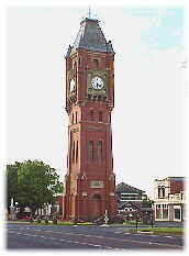
![]() Camperdown's
heritage & character is a feature of South West Victoria. The town
was named by Governor Charles LaTrobe in 1854 recognising
Scottish naval hero, Lord Viscount Adam Duncan who was Earl of
Camperdown. Due to the efforts of many local groups, the architecture
and beauty of Camperdown's unique buildings, wide streets and parks have
been preserved for all to see. Many of these buildings and features, which
date back to the mid 1800s, can be appreciated during heritage walking
tours of Manifold Street and other streets. Detailed information on such
walks and other interesting aspects of Camperdown can be obtained from
the Information Centre located within the old Court House
in Manifold Street..
Camperdown's
heritage & character is a feature of South West Victoria. The town
was named by Governor Charles LaTrobe in 1854 recognising
Scottish naval hero, Lord Viscount Adam Duncan who was Earl of
Camperdown. Due to the efforts of many local groups, the architecture
and beauty of Camperdown's unique buildings, wide streets and parks have
been preserved for all to see. Many of these buildings and features, which
date back to the mid 1800s, can be appreciated during heritage walking
tours of Manifold Street and other streets. Detailed information on such
walks and other interesting aspects of Camperdown can be obtained from
the Information Centre located within the old Court House
in Manifold Street..
.
![]() Camperdown
was established at the foot of Mount Leura and Mount Sugar loaf,
which are part of a much larger volcanic complex known as the Leura
Maar. A Maar is an uncommon land form, comprising a broad, roughly
circular, flat floored volcanic crater with steep inner walls and a low
surrounding rim made up of fragments of rock material blown out of the
crater during eruptions.
Camperdown
was established at the foot of Mount Leura and Mount Sugar loaf,
which are part of a much larger volcanic complex known as the Leura
Maar. A Maar is an uncommon land form, comprising a broad, roughly
circular, flat floored volcanic crater with steep inner walls and a low
surrounding rim made up of fragments of rock material blown out of the
crater during eruptions.
..
 .
.
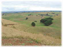
![]() The
growth of Mount Leura and Mt Sugar loaf began with explosive
bursts of lava being ejected into the air. Gases escaping from the lava
caused it to break in to gravel sized fragments called scoria which
fell back to the ground This now makes up the cones which provide
a wonderful back drop for the township
The
growth of Mount Leura and Mt Sugar loaf began with explosive
bursts of lava being ejected into the air. Gases escaping from the lava
caused it to break in to gravel sized fragments called scoria which
fell back to the ground This now makes up the cones which provide
a wonderful back drop for the township
![]() From
the summit of Mount Leura a spectacular view of the surrounding
district can be seen, which includes many of the other cones and
craters
associated with the basalt plain .
From
the summit of Mount Leura a spectacular view of the surrounding
district can be seen, which includes many of the other cones and
craters
associated with the basalt plain .
/
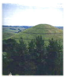
![]() Mount
Sugar loaf is a steep, near perfect cone made up of scoria rising as a
high point on the same crater rim as Mount Leura. It formed as a result
of perhaps several months of lava flowing from the same point in the crater.
.
Mount
Sugar loaf is a steep, near perfect cone made up of scoria rising as a
high point on the same crater rim as Mount Leura. It formed as a result
of perhaps several months of lava flowing from the same point in the crater.
.
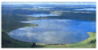
![]() Camperdown's
two lakes are one kilometre west of town in a twin volcanic crater,
separated only by a narrow stretch of land. Lake Gnotuk is salty
and 30 metres lower than Lake Bullen Merri, which has fresh water.
These lakes and many other lakes in this volcanic region are the result
of eruptions that occurred more than 10,000 years ago. After the eruptions
ceased, both craters became choked with rock debris, and the lakes developed.
The bottom of both lakes are about the same level [80 metres above sea
level] Bullen Merri has a steep cone shaped floor and is more than
60 metres deep, while lake Gnotuk has a flat floor and a depth of
less than 20 metres.
Camperdown's
two lakes are one kilometre west of town in a twin volcanic crater,
separated only by a narrow stretch of land. Lake Gnotuk is salty
and 30 metres lower than Lake Bullen Merri, which has fresh water.
These lakes and many other lakes in this volcanic region are the result
of eruptions that occurred more than 10,000 years ago. After the eruptions
ceased, both craters became choked with rock debris, and the lakes developed.
The bottom of both lakes are about the same level [80 metres above sea
level] Bullen Merri has a steep cone shaped floor and is more than
60 metres deep, while lake Gnotuk has a flat floor and a depth of
less than 20 metres.
.
.
© The Gateway BBS Camperdown Authors:Anton Art & John Hamilton